1. 引言
近年来,在全球变暖和快速城市化进程的背景下,城市地表高温热环境的形成变得尤为独特和复杂并对人们带来不利影响。例如,最为明显的城市热岛效应成为影响城市生态环境的主导因素之一,由此产生的极端气候事件、人类健康威胁和经济损失等均不容忽视 [1] - [9] 。大约54%的世界人口生活在城市地区,到2030年,随着城市群的出现和从农村到城市或郊区的人口迁移的继续,这一比例预计将增加到70% [10] 。城市地区快速的人口增长和人口聚集正在为政策制定者和公众创造社会问题。因此,开展城市地表热环境变化的时空监测研究,对理解城市气候变化特征以及城市发展和规划、生态绿色发展以及防灾减灾均具有重要意义。
遥感技术已被广泛认为是环境评估和城市规划不可或缺的工具,因为它可用于获得模拟环境影响人口增长和城市化时所必需的时空数据。基于卫星的城市化及其热环境影响评估受到越来越多的关注 [11] [12] [13] [14] ,主要卫星平台为NOAA/AVHRR [15] [16] [17] [18] ,EOS/MODIS [19] - [24] 和Landsat/TM [25] [26] [27] [28] [29] 。AVHRR资料的分辨率为1.1 km,其优势在于将复杂的城市下垫面区域简单地近似处理成粗糙单元,并能有效反映出城市温度空间分布,用于城市热岛形成的研究。相比之下,利用更高分辨率卫星如Landsat数据(空间分辨率为百米级)显示出长期监测城市化和城市热岛效应的优势。虽然高分辨率卫星资料能反映城市街区尺度,但其时间分辨率太低,而且资料不易获得,所以在应用中受到一定的限制。美国NASA发射了对地观测系统(EOS)卫星Terra和Aqua上搭载了中等分辨率成像光谱仪(MODIS)可以根据一定的算法对地表温度和植被指数等特征进行反演分析。与Landsat TM相比,它具有高时间分辨率和高光谱分辨率的优点,MODIS每1~2 d观测整个地球表面状况,可获得36个光谱通道资料,这些资料有助于精确地理解全球/区域甚至局地城市气候变化。例如,张佳华等 [3] 利用EOS/MODIS 遥感资料结合常规气象资料对北京地区2001年城市热岛空间分布的日变化和季节特征及其影响因子进行了研究;石涛等 [23] 利用Terra和Aqua搭载的MODIS反演的地表温度揭示了安徽省典型代表城市的热岛的年际、季节和日变化特征及其成因。易予晴等 [24] 利用多年的MODIS地表温度产品和遥感土地利用分类结果揭示了武汉城市群的夏季热环境分布特征,分析了城市群热环境日夜变化特征与土地覆盖类型的相关关系。因本文将重点关注基于MODIS的城市地表高温热环境遥感改进方法。
然而,由于自然地形、天气条件、人为改变边界层下垫面特征以及人为热源排放等多种因素影响 [30] - [35] ,加之卫星光学遥感监测地表温度的采样受云等影响较大 [36] [37] ,不同研究时次城市地表温度的时空分布特征是变动的,这使得城市热环境指标在实际城市规划和生态环境评估应用中存在一定的不足。城市规划管理需要一个稳定的热环境指标,由其得到的热环境空间分布特征不会出现明显的变化,能够反映城市热环境分布对人类生产生活的影响,人口越集中的区域,受城市高温热环境影响的人数越多,这样使得城市规划调整和建筑节能推广等工作才具有可操作性 [38] 。因此需要一个能综合考虑到人口分布因素来进行城市高温热环境区划监测指标,且在一定时空范围内形态分布相对稳定、可操作性较强,继而可有效对城市规划调整或者节能减排技术推广。已有研究表明,NPP/VIIRS (National Polar- orbiting Partnership, NPP; Visible Infrared imaging Radiometer Suite, VIIRS)是最新一代的夜间灯光遥感数据,卫星的传感器是由NOAA和NASA共同研制,相对于传统的数据具有更高空间分辨率和更大幅宽。NPP/VIIRS Day/Night Band (DNB)影像的空间分辨率约为0.5 km × 0.5 km,在实现人口和社会经济数据空间化的具有巨大潜力 [39] 。例如,其具有独特的低光源成像捕捉能力,能够有效探测城市及其周边地区的居住区以及工业和场矿的能耗特征,且NPP/VIIRS夜间灯光强度DNB像元灰度值与城市人口数量和城市建成区的扩张有着较好的关联度,从而成为人口的空间化和格网化分布反演的重要的数据来源 [39] 。
鉴于此,本文以安徽省北部代表城市蚌埠、安徽省中部代表城市合肥以及安徽省南部代表城市芜湖为研究对象,选取覆盖安徽省的MODIS地表遥感数据和NPP/VIIRS夜间灯光遥感影像,应用时间序列谐波分析和回归分析进行处理,同时选用人口、地表温度作为研究指标来表征热环境,构建一个考虑人口分布因素的且在一定时空范围内形态分布相对稳定、可操作性较强的城市热环境指标对代表城市夏季地表高温进行区划研究和评估。
2. 资料与方法
2.1. 研究区概况
本文综合气候、地理、人口、城市化程度等因素,选取了安徽省省会合肥、代表安徽省北部的蚌埠和代表安徽省南部的芜湖作为研究对象,具体位置见图1。合肥市为安徽省省会城市,安徽省第一大城市,地处江淮之间的丘陵地带和巢湖之滨;芜湖市是安徽省第二大城市,安徽省南部的经济中心,地处长江以南的沿江平原;蚌埠是安徽省的铁路交通运输枢纽重中心,地处淮河两岸的平原地带。
2.2. 资料来源及预处理
MODIS是美国地球观测系统(EOS)任务中太阳同步卫星上搭载的主要传感器。本文地表温度数据选用该卫星的陆地3级标准数据产品,空间分辨率1 km,过境时间10:30左右,这个时段处于地表升温时段,适合用于城市热环境特征的研究。NPP/VIIRS是最新一代的夜间灯光遥感数据,卫星的传感器是由NOAA和NASA共同研制,相对于传统的数据具有更高空间分辨率和更大幅宽。NPP/VIIRS影像的空间分辨率约为0.5 km × 0.5 km (表1)。

Figure 1. Geographical division of Anhui province and selected representative cities
图1. 安徽省地理分区情况及选取的代表城市
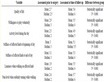
Table 1. Data types, sources, times, and accuracy of this article
表1. 本文的数据类型、来源、时次和精度
2.3. 谐波分析法
时间序列谐波分析法 [40] (Harmonic Analysis of Time Series, HANTS) (简称Hants)可以对时间序列数据进行平滑校正。Hants的核心计算方法为傅里叶变换和最小二乘法拟合,先将时间序列遥感影像的数据分解成不同频率的正弦和余弦曲线,然后筛选具有时间序列特征的曲线进行叠加运算,从而重新建立的平滑时间序列遥感影像。
Hants处理的流程是,首先将所有的离散数据生成最小平方的拟合曲线,然后检查每一个数据,逐个与拟合的曲线进行对比。当遥感影像上出现云层时,被干扰点的像元值会很低,将被程序视为云污染点,然后将这些点的权重赋为零,最终从拟合曲线上剔除。偏离阈值最大的点首先剔除,然后将剩余的点重新进行拟合生产曲线,最后检查每个数据,再剔除偏离阈值的点。多次循环这个过程,最后就能重新构建光滑的曲线。
2.4. 空间化人口反演
本文首先收集各区县的人口普查数据和NPP/VIIRS遥感数据,然后统计分析各区县行政边界范围内的夜间灯光强度数据,通过回归分析得到各区县内夜间灯光强度与普查人口的函数关系 [39] ,见公式(1)。
(1)
式中,
为第i区县的统计普查人口;DNVIIRS为NPP/VIIRS的像元灰度值;∑DNVIIRS为第i区县范围内NPP/VIIRS的像元灰度值总和。
根据上述函数关系,可以在ARCGIS中完成人口的空间化数据,再对各县区的人口数据进行统计,求得各区县普查人口数与各区县空间化人口数据的订正系数bi:
(2)
其中,bi为第i区县范围内人口格网订正系数,
为该区县普查人口数,Pi为通过回归方程得到的第i区县的人口统计数。
然后将比例系数与各个单元格上的空间化人口数据相乘,最终得到修正的空间化人口数据:
(3)
其中,
为订正后的第i区县每个格网单元上分布的人口数量,
为由回归方程求得的第i区县内每个栅格单元上分布的人口数量。
2.5. 人口加权的城市地表高温区划指标
根据张立杰等人研究 [38] ,城市规划管理需要一个稳定的热环境指标,由其得到的热环境空间分布特征不会出现明显的变化,一方面能够反映城市热环境分布对人类生产生活的影响,另一方面由于人口越集中的区域,受城市热环境影响的人数越多,这样使得城市规划调整和建筑节能推广等工作才具有可操作性。为了满足上述这样要求 [38] ,本文设计了基于MODIS和人口加权的城市地表高温区划指标(Population Weighted Urban Surface High Temperature Regionalization Index),其大小用IPWUSHTR表示。
(4)
式中,N(x)为归一化函数,UTE为由MODIS遥感数据反演得到的城市地表温度,P为空间化人口数据。再根据得到的人口加权城市地表高温区划指标的大小,采用ArcGIS默认的Natural Breaks方法进行分级。
3. 结果与分析
3.1. 谐波分析重构遥感影像
图2(a)为经过剪裁镶嵌和投影转换的MODIS原始数据,可以看到,原始影像中存在单独或大片空白的斑块,即较为严重的云层遮挡现象。图2(b)为经过时间序列谐波分析处理过的影像,经过对比可以发现原图中所有的云污染点和斑块被去除,Hants重新构成了平滑的时间序列遥感影像。
此外,从同一研究区域的光谱曲线对比图上看,对于原始光谱曲线(图3(a))上那些明显低于正常数值的点,Hants可以将它们的权重赋为零而剔除参与曲线拟合,最终形成一条新的光滑曲线(图3(b))。
3.2. 夜间灯光数据反演人口
根据2.4节中空间化人口反演方法,将各区县普查人口数与NPP/VIIRS像元灰度值进行回归分析。如图4所示,各区县人口数与像元灰度值相关性较为显著,决定系数R2达到了0.7516,因而NPP/VIIRS夜间灯光数据适用于人口空间化分析。
由此得到的人口数与夜间灯光数据NPP/VIIRS像元灰度值函数关系,如下所示:
根据上面得到的函数关系,通过Arc GIS计算NPP/VIIRS每个栅格单元上的初始人口数,由此可统计出第i区县行政区划范围内的初始人口数
。
已有研究表明,由于拟合曲线存在一定的误差,每个区县初始人口数与实际普查人口数
并不完全符合 [39] ,因此,根据公式(2)和(3)分别构建了各个区县的人口栅格模型比例系数bi,然后将各个区县的遥感反演初始人口栅格值PGridi乘以相应的比例系数,使各区县栅格模型人口总数量与普查人口数量相等,得到最终的空间化人口数据。
3.3. 基于MODIS遥感的夏季城市地表高温区划
经过行政区划掩膜提取和时间序列谐波分析之后,我们可以得到皖北代表城市蚌埠、皖南代表城市

Figure 2. Contrast of original image (a) and harmonic analysis images (b)
图2. 原始影像(a)和谐波分析影像(b)对比图

Figure 3. The original spectral curve (a) and harmonic analysis spectral curve (b)
图3. 原始光谱曲线(a)和谐波分析光谱曲线(b)

Figure 4. General population and NPP/VIIRS scatter plot
图4. 普查人口与NPP/VIIRS散点图
芜湖以及皖中代表城市合肥的遥感影像地表温度分布情况,之后再进行归一化处理和Nature Break地表温度分类,可以得到基于MODIS的安徽代表城市地表高温热环境区划(LT,SLT,MT,SHT and HT分别代表low,sub-low,medium,sub-high and high temperature zones,即低温区(LT)、亚低温区(SLT)、中温区(MT)、亚高温区(SHT)、高温区(HT)) 。
如图5所示,2014年夏季蚌埠、合肥和芜湖(图5(a)、图5(b)、图5(c))三个代表城市均出现了不同程度的热岛效应,高温区主要集中在城市中心区域,通过GIS软件的统计分析给出2014和2015年夏季MODIS监测到的不同热环境等级面积比例,具体见表2。高温区在三个城市所占的面积比重分别达到了7.37%、14.47%、11.99%;三个城市的热环境等级面积以中温区为最高,均在30%以上;亚高温和亚低温的面积比例在20%~30%之间;而低温区的面积比例都在10%以下。
对比来看,2015年夏季(图5(d)、图5(e)、图5(f))三个代表城市的中心区域同样出现了大块的高温区,但是将2015年的夏季高温区划与2014年夏季进行对比,可以发现两者高温区出现的区域和斑块形状变化较大,两个时次的高温分布特征之间并没有呈现出明显的规律。同样通过GIS软件的统计分析具体见表2。看出高温区在三个城市所占的比重也有所增加,分别为7.6%、16.22%、16.55%。但是三个城市的热环境等级面积不再以中温区为最高,蚌埠和芜湖以亚低温最高,面积比例分别为32.8%和31.59%,合肥以亚高温最高,面积比例分别为32.19%;而低温区的面积比例仍然都在10%以下。综合来看,2015年的夏季热环境分布与2014年夏季的空间分布和不同热环境等级的面积比例的最大值均发生了较为显著的变化。


Figure 5. Based on MODIS monitoring, 2014 (A.B, c) and 2015 (D, e, f), Anhui representative cities (Bengbu (a, d), Hefei (B, e), Wuhu (C, f)), summer surface heat regionalization
图5. 基于MODIS 监测的2014年(a.b,c)和2015年(d,e,f) 安徽代表城市(蚌埠(a,d)、合肥(b,e)、芜湖(c,f))夏季地表高温区划
3.4. 基于人口加权的MODIS遥感夏季城市地表高温区划
根据公式(4),得到人口加权的MODIS遥感热环境指标的空间分布,2014年夏季(图6(a)、图6(b)、图6(c))三个代表城市的中心区域也出现了高温区域,而2015年夏季(图6(d)、图6(e)、图6(f))的高温区面积有所增加,并且是在2014年夏季原有的高温区域上进行拓展,两者在高温区出现的区域和斑块形状上具有较强的连续性和相似性,且低温区面积的空间形态十分稳定,通过人口加权之后的低温区面积比例为最高而且最为稳定,符合城市周边的实际情况。
具体来看,从空间分布上来看,城市的高温区主要集中在城市中心区域,通过GIS软件的统计分析给出2014和2015年夏季人口加权后的不同热环境等级面积比例,具体见表3。2014年高温区在三个城市所占的面积比重分别达到了4.69%、9.05%、6.85%。2015年夏季三个代表城市的中心区域同样出现了大块的高温区,高温区在三个城市所占的比重也有所增加,分别为4.67%、13.96%、8.61%。三个城市的热环境等级面积以低温区为最高,芜湖和蚌埠均在30%以上,合肥在25%以上;蚌埠和芜湖亚低温的面积比例在20%~30%之间,而合肥的在15%左右;而高温核心区域的面积比例基本都在10%以下,除了合肥2015年在10%,这与合肥市的快速城市化和人口发展也有密切相关。
综上说明,本文构建的人口加权热环境指标是一个形态分布相对稳定、应用性较强的城市地表高温区划指标,从城市规划和管理、生态环境监测的角度出发,能够在这些区域采用城市规划管理或者节能减排技术,发展绿色生态环保技术,缓解城市热环境格局不均衡造成和加剧的夏季高温热浪。同时,由于引入了最新的NPP/VIIRS夜间灯光强度数据(500米 × 500米),使得人口加权城市地表高温区划指标
Table 2. Based on the proportion of area of different thermal environment grades in MODIS 2014 and 2015 summer
表2. 基于MODIS 2014和2015年夏季的不同热环境等级面积比例
Table 3. Based on the population weighted thermal environment index, the proportion of different thermal environment grades in summer of 2014 and 2015 was studied
表3. 基于人口加权热环境指标的2014和2015年夏季不同热环境等级面积比例


Figure 6. Based on population weighted MODIS monitoring, 2014 (A.B, c) and 2015 (D, e, f), Anhui representative cities (Bengbu (a, d), Hefei (B, e), Wuhu (C, f)), summer surface heat regionalization
图6. 基于人口加权的MODIS监测2014年(a.b,c)和2015年(d,e,f) 安徽代表城市(蚌埠(a,d)、合肥(b,e)、芜湖(c,f))夏季地表高温区划
的空间分辨率相对于传统的地表热环境数据有了较大的提升。
4. 结论与讨论
1) NPP/VIIRS相对于传统夜间灯光数据而言,空间分辨率和光谱分辨率有了大幅的提高。通过构建反演模型以及各个县区校正系数的确定,各县区普查人口数量与对应的夜间灯光强度有着比较好的相关性,基于夜间灯光遥感影像反演得到的空间化人口数据,不但在数量上接近实际人口,而且在表征各个县区人口空间分布的内部特征上具有一定的优越性,能够真实的反应出研究区域内人口分布的差异性。
2) 原始MODIS影像中存在单独或大片空白的斑块,即较为严重的云层遮挡现象,导致原始数据偏低,不能直接用于年际空间分布特征分析。时间序列谐波分析不仅可以对这种现象给予有效订正,而且能较好地保留原始数据的高质量信息,重新构成平滑的时间序列遥感影像,适合用于热环境空间分布特征的研究。
3) 人口加权的地表高温区划指标相对于传统的单一使用遥感数据进行反演更加科学合理。一方面可以大幅提高空间分辨率,细化城市热环境的空间分布特征;另一方面该指标是一个形态分布相对稳定、可操作性较强的城市地表高温区划指标,从城市规划和管理的角度出发,能够在这些区域采用城市规划管理或者节能减排技术,发展绿色生态环保技术,缓解城市热环境格局不均衡造成和加剧的夏季高温热浪。
目前我国正处在工业化和城镇化快速发展的历史阶段,气候变化对城市的建设发展、能源、交通、通信等基础设施安全和人民生产生活已经并将持续产生重大影响,积极建设气候适应型城市,事关城市可持续发展,是生态文明建设的一项重大课题。未来我们将继续探究影响城市热环境分布的其他因素,将把城市的地形、建筑物的布局等影响因子加入到城市地表高温热环境指标中,从而进一步完善城市地表高温区划的遥感监测指标体系。
基金项目
中国气象局气候变化专项(CCSF201726),国家自然科学基金项目(41205126),中国气象局人才专项,安徽省气象局创新团队计划和安徽省气象局科技发展基金(KM201520)共同资助。