1. 引言
土壤侵蚀是地球表面的一种自然现象,是指地球表面的土壤及其母质在水力、风力、冻融、重力等外力的作用及人为因素影响下发生的各种破坏、分离、搬运和沉积的现象 [1] ,中国是世界上土壤侵蚀最严重的国家之一,对水土流失的防治已受到政府和全社会的普遍关注。通用土壤流失方程(USLE)是60世纪70年代Wischmeier等提出的一种主要利用GIS软件的栅格数据代数叠加运算功能,将六因子栅格图相乘,从而得到每个栅格的侵蚀模数。具有结构简单、数据易于获取、结果可靠等特点,被广泛的应用到了土壤侵蚀的调查研究中。例如,蔡崇法 [2] 等人依据实地调查资料,建立了典型小流域地理数据库;应用径流小区观测结果,确定了定量计算土壤流失方程USLE因子指标的方法;高峰 [3] 等人在GIS和RS技术支持下,基于USLE模型对钦江流域土壤侵蚀进行了定量评估,并分析了不同海拔、不同坡度、不同土地利用类型下土壤侵蚀强度特征和规律;潘美慧 [4] 等人基于通用土壤流失方程(USLE),运用遥感和地理信息技术对东江流域年均土壤侵蚀量进行估算。本文在前人的调查与研究的基础上,将六因子相结合进行计算与分析并选取最适宜于该地区的因子的计算模型,同时将遥感数据与收集到的较为全面的调查数据相结合,提高了土壤侵蚀定量化研究的精度。
黑土是自然肥力最高的农用土壤之一。东北黑土区作为我国重点粮食生产基地,其粮食生产能力关系到我国的粮食安全战略。由于近几十年来不加节制的开垦耕作,导致黑土功能退化,土壤侵蚀日趋严重 [5] 。伊通满族自治县位于东北吉林省中南部,是全国商品粮基地县之一,单产位居全省第一,过度的土地开发和不科学的生产经营方式使该地区的土壤侵蚀得以加剧,成为阻碍该地区发展的主要问题之一,因此对该地区的侵蚀特征及影响因子进行分析,为相关部门进行水土流失防治、生态环境的改善提供了决策依据。
2. 数据来源和研究区概况
2.1. 数据准备
本研究的基础数据包括:1) 遥感数据:2016年高分一号(2米全色,8米多光谱);2.1米资源三号卫星影像。2) 该县气象站的近30年的逐日侵蚀性降雨量资料。3) 数字矢量化后的该县的土地利用图。4) 数字化后的该县土壤图,其中包括土壤类型、质地、有机质等属性信息。5) 该县水土流失治理项目可研、初步设计报告及附图表。6) 该县的10 m分辨率的DEM数据。
2.2. 研究区概况
伊通满族自治县位于吉林省中南部,地理坐标为124˚49'E~125˚46'E、43˚3'N~43˚38'N。幅员面积2533.11平方公里,地处于长白山脉向松辽平原过渡的丘陵地带,西北部和东南部地区属大黑山脉和哈达岭余脉,多数为连绵起伏的低山丘陵,占该县总面积的60.8%。属温带大陆性季风气候,气候特点为年平均气温5.5˚C,年平均降水量达654.7毫米,全县共有河流128条,较大的为伊通河和孤山河。
3. 土壤侵蚀强度计算与空间分析
本研究中土壤侵蚀计算采用的模型是美国W. H. Wischmeier [6] 等1965年提出的通用土壤流失方程USLE,该模型主要利用GIS软件的栅格数据代数叠加运算功能,将六因子栅格图相乘,得到每个栅格的侵蚀模数。
USLE模型的基本形式为:

式中,A为预测土壤侵蚀量,R为降雨侵蚀力因子;K为土壤可蚀性因子;L为坡长因子;S为坡度因子;C为覆盖与管理因子;P为水保措施因子。
3.1. 模式因子的确定
3.1.1. 降雨侵蚀力因子(R)
降雨侵蚀力是定量评估土壤水蚀的首要影响因子,表征降雨引起侵蚀的潜在能力,与降雨量、降雨历时、降雨动能等密切相关,反映了降雨特性对土壤侵蚀的影响 [7] 。国内外众多学者针对各研究区的特征,提出了基于年、月、日降雨量资料来计算降雨侵蚀力因子的简易算法。由于日降雨量数据是目前为止气象部门公开发布的最详细的数据资料,为此,本研究采用日雨量计算降雨侵蚀力的模型。
3.1.2. 土壤可蚀性因子(K)
土壤可蚀性因子(K)值的大小表示土壤被侵蚀的难易程度,反映土壤对侵蚀外营力(降雨、径流、地形、地表植被和人为活动)剥蚀和搬运的敏感性,是影响土壤流失量的内在因素 [8] 。本研究计算K值采用的方法是Williams等人在EPIC模型中发展的土壤可蚀性因子K的估算方法进行计算 [9] 。
3.1.3. 坡度坡长因子(LS)
地形特征对土壤侵蚀的影响通常用坡长因子L和坡度因子S来反映,坡度坡长的,在研究时通常将他们放在一起考虑。本研究采用的LS算法采用1987年由McCool等人在1987年提出并由国内学者刘元宝等 [10] 改进的计算公式。
3.1.4. 覆盖与管理因子(C)
覆盖与管理因子C指的是在某种状态下地块上种植的作物的土壤流失与其相应的清耕、连续休闲地块上流失量的比值。因此,C值得大小与土地利用类型息息相关。本研究主要参考黑龙江省黑土区C因子的实测及研究结果 [11] [12] ,参考美国农业部农业手册282号文件中有关C因子值的内容,结合2016年该县土地利用图,对不同土地利用类型C因子进行赋值。
3.1.5. 水保措施因子(P)
水土保持措施因子P是指采用水土保持措施的土壤侵蚀量与采用顺坡种植时土壤侵蚀量的比值,为无量纲数,介于0、1之间 [13] ,没有侵蚀的地方P值为0,未实施水保措施的地方P值为1。水土保持措施因子的计算是基于高分辨率卫星遥感影像,进行野外调查,根据调查结果结合该县的可研和初步设计报告获取。
3.2. 土壤侵蚀强度计算
在ArcGIS中利用栅格计算器将六因子相乘得到该县土壤侵蚀模数,可知该县平均土壤侵蚀模数为1046.03 t/km2∙a,将此运算结果按照黑土区水土流失综合防治标准(SL446-2009) (如表1)将土壤侵蚀强度分为微度侵蚀、轻度侵蚀、中度侵蚀、强烈侵蚀、极强烈侵蚀、剧烈侵蚀,计算出不同强度侵蚀面积。
依照上述标准,计算出伊通县侵蚀总面积为991.44 km2,占本县土地总面积的39.14%。以中度侵蚀为主,面积为494.85 km2,占侵蚀总面积的49.91%;强烈侵蚀面积为168.58 km2,占17.00%,轻度侵蚀面积为156.59 km2,占15.79%,剧烈侵蚀面积为102.12 km2,占10.30%,极强烈侵蚀面积为69.3 km2,占6.99% (见图1)。
与第一次全国水利普查(2011年)结果对比,该县总侵蚀面积减少41.03 km2,其中轻度侵蚀、极强烈侵蚀都有所减少,分别减少223.52 km2、58.33 km2,中度侵蚀、强烈侵蚀、剧烈侵蚀有所增加、分别增加了202.34 km2、4.77 km2、33.71 km2 (见图2)。
3.3. 土壤侵蚀强度的空间分布
做出2016年伊通县水土侵蚀强度的空间分布(见图3),在整个研究区内,微度侵蚀主要成片分布于该县南部、东南部、西南部;轻度侵蚀呈零星分布于该县;中度侵蚀主要成片分布于该县北部和西南部;强烈侵蚀和剧烈侵蚀主要分布于该县西北部和东部,极强烈侵蚀呈零星分布,面积较少。
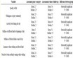
Table 1. Black soil area at the water loss and soil erosion prevention standards (SL446-2009) of soil erosion intensity classification standard table
表1. 黑土区水土流失防治标准(SL446-2009)土壤侵蚀强度分级标准表

Figure 1. 2016 Yitong Manchu Autonomous County soil erosion intensity grade area composition map
图1. 2016年伊通满族自治县土壤侵蚀强度等级面积构成图

Figure 2. Comparison of soil erosion area in Yitong Manchu Autonomous County between 2016 and 2011 (unit: km2)
图2. 2016年与2011年伊通满族自治县土壤侵蚀面积对比图(单位:km2)
4. 不同因子对土壤侵蚀的影响分析
4.1. 土地利用类型对土壤侵蚀的影响
基于资源三号和高分一号遥感影像,采用人工目视解译并结合野外调查获取伊通满族自治县土地利用图(图4)。本研究中根据需要及伊通县地物实际情况将土地利用类型分为:水田、旱地、林地、草地、居民点及工矿交通用地、水域及水利设施用地、裸岩或裸地。
从土地利用图中看出,该县主要以旱地和有林地为主,旱地、居民点和河流分布于伊通县全境,有林地主要分布在西北和东南地区,较大的水域主要分布在伊通县的西南部。县域土地利用中耕地面积最大,为1668.49 km2,占总土地利用的65.87%;其次为林地和居民点及工矿交通用地,面积为557.54 km2、171.84 km2,分别占22.01%、6.78%;水域及水利设施用地、草地,面积为80.11 km2、55.10 km2,分别占3.16%、2.18%;面积最小为其它土地利用。
将该县的土地利用图与土壤侵蚀图进行叠加,可知该县不同土地利用类型的平均土壤侵蚀模数分别为:水田449.23 t/km2∙a、旱地1550.85 t/km2∙a、林地470.60 t/km2∙a、草地91.68 t/km2∙a、居民点及工矿交通用地192.94 t/km2∙a、水域及水利设施用地16.04 t/km2∙a、裸岩或裸地13068.91 t/km2∙a,并计算出不同

Figure 3. Spatial distribution of soil erosion in Yitong Manchu Autonomous County in 2016
图3. 2016年伊通满族自治县土壤侵蚀空间分布图

Figure 4. Land use map of Yitong Manchu Autonomous County in 2016
图4. 2016年伊通满族自治县土地利用图
土地利利用类型轻度、中度、强烈、极强烈、剧烈、侵蚀总面积以及其所占该类型土地的总面积的比例(见表2)。
由表2可以看出:
不同土地利用类型侵蚀差异较大,水田主要以轻度侵蚀为主,旱地主要以中度侵蚀为主,林地主要以中度侵蚀为主,草地主要以轻度侵蚀为主,居民点及工矿交通用地主要以轻度侵蚀为主,水域及水利设施用地主要以中度侵蚀为主,其他土地利用主要以剧烈侵蚀为主。
所有土地利用类型中,旱地侵蚀最为严重,占旱地总面积的56.26%。主要是由于人民的利益需求与社会发展的需要,对山坡地进行不合理的开发和经营,同时该县经济以农业为主,经济作物为辅,农村生产力水平低下、治理资金不足,没有及时的进行人工保护措施加之垦荒严重造成了这样的后果。
不同土地利用类型平均土壤侵蚀模数大小关系为:裸岩或裸地> 旱地 > 林地 > 水田 > 居民点及工矿交通用地 > 草地 > 水域及水利设施用地。不同类型土地利用类型侵蚀面积大小关系为:旱地 > 林地 > 居民点及工矿交通用地 > 水域及水利设施用地 > 草地 > 水田 > 其他土地利用。不同类型土地利用总侵蚀占土地利用面积比例大小关系为:裸岩或裸地 > 旱地 > 水田 > 居民点及工矿交通用地 > 草地 > 林地 > 水域及水利设施用地。由此可知,裸岩或裸地所面积较少,但所占侵蚀比例却很大并且全部属于剧烈侵蚀,属于高危土壤侵蚀,要加强预防,进行生态修复;该县林草地及水域侵蚀相对而言较少,具有良好的水土保持功能,地表径流较少,与该县加强草地的管理、禁止过度放牧、政府出台相应措施密不可分。
4.2. 坡度对土壤侵蚀的影响
基于10 m分辨率的DEM数据,并利用ArcGIS软件计算该县的坡度,得出该县平均坡度为5.32˚,
Table 2. Soil erosion intensity, area and proportion of different land use types in Yitong Manchu Autonomous County in 2016
表2. 伊通满族自治县2016年不同土地利用类型侵蚀强度面积及比例
将坡度根据《土壤侵蚀分类分级标准》(SL190-2007) (见表3)将坡度分为六级,计算不同级别坡度侵蚀强度及比例。
根据得到的该县坡度分布图(图5)可知该县主要以0˚~3˚坡度为主,主要位于该县西南部呈片状分布,结合土地利用图来看与旱地的分布相吻合。
将该县坡度分布图与土壤侵蚀图进行叠加,计算出不同坡度分级下轻度、中度、强烈、极强烈、剧烈、侵蚀总面积以及其所占总面积的比例(见表4)。
由表4可知:
1) 不同坡度下侵蚀差异较大,坡度为0˚~8˚主要以中度侵蚀为主,8˚以上主要以剧烈侵蚀为主。在不同的坡度条件下,坡度越低侵蚀越微弱,坡度越高侵蚀越剧烈。
2) 不同坡度下侵蚀面积大小关系为:0˚~3˚ > 8˚~15˚ > 3˚~5˚ > 5˚~8˚ > 15˚~25˚ > 25˚以上,即侵蚀面积越大,侵蚀程度越弱,侵蚀面积越小,强势强度越剧烈。不同坡度下总侵蚀占土地利用面积比例大小关系为:25˚以上>3˚~5˚ > 5˚~8˚ > 8˚~15˚ > 15˚~25˚ > 0˚~3˚。
4.3. 高程对土壤侵蚀的影响
基于10 m分辨率的DEM数据,并利用ArcGIS软件计算该县的高程,得出该县平均高程为5.32˚,根据研究区地貌特征,将研究区高程六个等级(见表5),计算不同级别高程下侵蚀强度及比例。
根据该县高程分布图(图6)可知该县主要以0 m~250 m高程为主,主要位于该县西南部呈片状分布,
Table 3. National standards for slope classification
表3. 坡度分级国家标准
Table 4. Intensity, area and proportion of erosion under different slopes in Yitong Manchu Autonomous County
表4. 伊通满族自治县不同坡度下侵蚀强度面积及比例

Figure 5. Spatial distribution of slope in Yitong Manchu Autonomous County
图5. 伊通满族自治县坡度空间分布图

Figure 6. Spatial map of elevation of Yitong Manchu Autonomous County
图6. 伊通满族自治县高程空间分布图
结合土地利用图来看与旱地的分布相吻合。
将该县高程分布图与土壤侵蚀图进行叠加,计算出不同高程分级下轻度、中度、强烈、极强烈、剧烈、侵蚀总面积以及其所占总面积的比例(见表6)。
由表6可知:
1) 不同高程下侵蚀差异较大,0 m~350 m主要以中度侵蚀为主,350 m以上主要以剧烈侵蚀为主。
2) 高程位于350 m以下为侵蚀发生的主要区域,主要是由于这一区域为人类活动范围,人类对大自然过度的放牧与砍伐造成了土壤侵蚀这一严重的后果,这一区域也将是治理水土流失的重点。
4.4. 植被盖度对土壤侵蚀的影响
该县植被盖度范围位于0、1区间内,该县平均植被盖度为0.60,根据研究区植被特征将研究区植被盖度分为五个等级(见表7)。据此做出该县的植被盖度空间分布图(见图7),并计算不同强度植被盖度下侵蚀强度的面积及比例。
该县属于低覆盖地类区间内的土地利用面积为431.23 m2,占总面积的17.02%;属于中低覆盖地类区间内的土地利用面积为229.08 km2,占总面积的9.04%;属于中覆盖地类区间内的土地利用面积为392.37 km2,占总面积的15.49%;属于中覆盖地类区间内的土地利用面积为392.37 km2,占总面积的15.49%;属于中高覆盖区间内的土地利用面积为562.14 km2,占总面积的22.19%;属于高覆盖地类区间内的土地
Table 5. Grading standard of research area
表5. 研究区高程分级标准
Table 6. Area, intensity and area of erosion intensity in Yitong Manchu Autonomous County under different elevations
表6. 伊通满族自治县不同高程下侵蚀强度面积及比例
Table 7. Grading standard of vegetation coverage in study area
表7. 研究区植被盖度分级标准

Figure 7. Spatial distribution of vegetation coverage in Yitong Manchu Autonomous County
图7. 伊通满族自治县植被盖度空间分布图
利用面积为918.29 km2,占总面积的36.25%。
将该县植被盖度分布图与土壤侵蚀图进行叠加,可知该县不同植被盖度下的平均土壤侵蚀模数分别为:低覆盖1185.73 t/km2∙a;中低覆盖1595.91 t/km2∙a;中覆盖1364.18 t/km2∙a;中高覆盖1156.36 t/km2∙a;高覆盖823.02 t/km2∙a,并计算出不同植被盖度分级下轻度、中度、强烈、极强烈、剧烈、侵蚀总面积以及其所占总面积的比例(见表8)。
由表8可知:
1) 不同覆盖地类均以中度侵蚀为主,占总侵蚀面积的49.91%,而其中以高覆盖类草地中度侵蚀的面积最大。
2) 不同植被盖度分级下平均土壤侵蚀模数大小关系为:中低覆盖地类 > 中覆盖地类 > 低覆盖地类 > 中高覆盖地类 > 高覆盖地类;不同植被盖度分级下侵蚀面积大小关系为:中高覆盖地类 > 高覆盖地类 > 中覆盖地类 > 低覆盖地类 > 中低覆盖地类;不同植被盖度分级下总侵蚀占土地利用面积比例大小关系为:中低覆盖地类 > 中覆盖地类 > 低覆盖地类 > 中高覆盖地类 > 高覆盖地类。植被盖度越高
Table 8. Degree of vegetation coverage, erosion intensity, area and proportion of different grades in Yitong Manchu Autonomous County
表8. 伊通满族自治县不同等级植被覆盖度侵蚀强度面积及比例
侵蚀越弱,植被盖度越低侵蚀越强。
5. 结论
1) 伊通满族自治县主要以轻度侵蚀为主,占总侵蚀面积的49.91%,强烈、轻度、剧烈、极强烈侵蚀所占比例依次减少。空间分布上,微度侵蚀主要成片分布于该县南部、东南部、西南部;轻度侵蚀呈零星分布于该县;中度侵蚀主要成片分布于该县北部和西南部;强烈侵蚀和剧烈侵蚀主要分布于该县西北部和东部,极强烈侵蚀呈零星分布,面积较少。与第一次全国水利普查结果相比,侵蚀面积减少了41.03 km2。
2) 伊通满族自治县土地利用类型主要以旱地和林地为主,旱地主要以坡耕地的形式存在。旱地占总面积的65.87%,旱地侵蚀占总侵蚀的91.60%,其中有10.79%属于轻度侵蚀、52.96%属于中度侵蚀、18.07%属于强烈侵蚀、7.38%属于极强烈侵蚀、10.81%属于剧烈侵蚀。
3) 该县坡度主要以于0˚~3˚区间为主,面积为1108.78 km2,占总面积的43.77%。0˚~3˚侵蚀占总侵蚀的36.05%,其中有19.38%属于轻度侵蚀、69.42%属于中度侵蚀、11.18%属于强烈侵蚀、0.02%属于极强烈侵蚀。
4) 该县高程主要以250 m~300 m区间为主,面积为922.25 km2,占总面积的36.40%。250 m~300 m侵蚀占总侵蚀的41.28,其中有15.21%属于轻度侵蚀、52.85%属于中度侵蚀、18.33%属于强烈侵蚀、6.12%属于极强烈侵蚀、7.48%属于剧烈侵蚀。
5) 该县植被盖度主要以高覆盖地类为主,面积为918.29 km2,占总面积的36.25%。各级别植被盖度地类侵蚀面积差别不大,面积依次为中高覆盖地类25.08%、高覆盖地类22.49%、中覆盖地类19.81%、低覆盖地类19.63%、中低覆盖地类12.98%。
项目支持
全国水土流失动态监测与公告项目。
NOTES
*通讯作者。