1. 引言
随着我国城市化进程的推进,注重交通机动化带来的交通拥堵能源短缺以及环境污染逐渐加剧,极大地降低了人们的生活质量。Chris Bradshaw于1994年提出以步行、自行车和公共交通为主导模式的绿色交通体系概念,如果交通系统的绝大部分能够作为“绿色移动”而发生,通过步行,骑车或公共交通的话,对建设社会公平的城市交通有着非常重要的意义。目前关于绿色交通评价标准上要求上,戴欣[1] 对评价社区交通出行生态水平的指标体系进行了分析,基于交通出行数据采集的客观评价和基于居民满意度问卷调查的主观评价相结合的评价方式。李敏[2] 建立Logit回归模型,对影响居民选择绿色出行方式的因素进行了分析;蒋育红[3] 初步建立了绿色交通评价指标体系,并应用价值函数法进行评价。李宝鑫[4] 对美国LEED标准、新加坡Green Mark标准和国家绿标中的绿色交通内容进行了对比分析,采用各标准的优点并完善不足,提出生态城中绿色交通指标体系。从已有研究来看,绿色交通评价标准中一方面是对绿色交通基础设施提出要求,另一方面是对导向性规定,设施和导向性规定均是为绿色交通出行提供一定的环境,但目前没有一种很好的方法去评估绿色交通发展的环境。本文在借鉴已有研究成果的基础上,以城市建筑物为研究对象,利用可达性模型对城市交通出行环境进行一系列评估,对不同区域的可达性进行比较,找出差异化因素,来促进城市绿色交通的发展。
2. 可达性评估绿色交通发展环境的概念
2.1. 可达性定义
可达性概念从古典的区位论中产生,被看作反映交通成本的基本指标。国外学者对可达性定义可以归为五类:(1) 空间阻隔度量(Spatial Separated Measure)定义可达性是克服空间阻隔的难易程度[5] ,把两个节点间的空间阻隔(出行距离、出行时间或出行费用表示)作为可达性的数值,阻隔越小,可达性越好;(2) 累积机会度量(Cumulative Opportunity)定义可达性为个体从出发地利用某种交通方式在一定出行范围内能够接触到的工作机会的数量[6] ;(3) 空间相互作用度量(Space Interaction Measure),把可达性定义为相互作用的潜力[7] ,认为可达性不仅与两点间的空间阻隔(称为阻抗或者摩擦因子)有关,还与起点或终点活动规模的大小有关[8] ;(4) 效用度量(Utility Measure),以离散选择模型为理论依据,假定出行终点会赋予个体一定的效用,而个体会选择效用最大的终点出行,可达性是出行选择的最大期望效用,用对数和的形式表示[9] ;(5) 时空约束度量(Time Space Measure),从个体角度出发,在特定的时空约束下,以个体能够到达的时空区域来度量可达性水平[10] ,通常用时空棱柱来形象的表示,反映了个人出行的时间和空间范围。
本文采用累积机会度量模型,把可达性定义为建筑物内的个体从出发地利用交通网络在一定出行范围内能够到达的活动场所数量。交通出行是关于可达性的函数,活动目的地与出发地的邻近程度,会影响到人们的出行距离、模式,不同活动场所之间的邻近程度会影响到交通出行的选择。根据本文选取的可达性定义,可达性计算模型用公式(1)表达:
选取的可达性定义,可达性计算模型用公式1表达:
 (1)
(1)
 ——城市中某个建筑物的累计机会数量;
 ——城市中第
 类活动场所;
 ——城市中第
 个建筑物;
个建筑物;
 ——城市中
——城市中 类型活动场所中第
 j 个活动场所;
 ——建筑i 到活动场所
 处的出行距离;
 ——建筑物到活动场所的距离阈值;
 ——城市交通网络;
 ——活动场所j 的权重。
公式(1)表示的是以建筑物i 为中心 ,沿着城市交通网络
 在出行距离r 内能够到达第
 类型活动场所的个数(
 默认为1),其计算的可达性指标与城市交通网络(道路网络、公共交通网络以及轨道交通网络等)、交通转换节点(公交站点、地铁站)、活动场所数量和分布以及建筑物分布等决定,原理如图1所示,在GIS系统中,首先将建筑物和服务场所抽象为点,然后将这些抽象点和城市交通网一起建立拓扑网络集,最后利用网络分析工具计算,计算过程主要利用MIT的Sevtsuk A.等[11] 开发的UNA(Urban network analysis)工具实现。在分析时,与郭清华[12] 利用可达性概念和地理信息系统提出交通方式可达性差距指数类似,基于这样的假设,在短距离内,建筑内的人能够到达服务场所个数越多,种类越多,越容易采用步行或者自行车出行;在长距离内,建筑内的人通过公共交通与通过私人小汽车的可达性指标差异越小,越容易采用公共交通出行。
2.2. 绿色交通发展环境评估方法
城市绿色交通发展环境的评估是对步行和公共交通环境的评估,基于上面可达性指数的计算,通过在步行范围内城市活动场所、公交站点以及公交线路三个方面的累计机会来判断人们采用绿色出行的方便程度及可能性。活动场所功能主要由服务设施类型决定,因此绿色交通发展环境第一个方面是步行范围内服务设施的可达性,服务设施包含人们生活中的各个方面,包括商业购物、餐饮、公园、银行服务点等;第二个方面是步行范围内公交站点的可达性,包括公交站点的个数及站点所包含的公交线路数;第三个方面是对公共交通的可达性评估,主要是指乘坐公共交通能够达到的范围。
本文在对不同区域之间的绿色交通发展环境进行评估时,分为以下五个步骤。
Step1:计算各个建筑的不同功能可达性分析;
Step2:进行可达性比较;
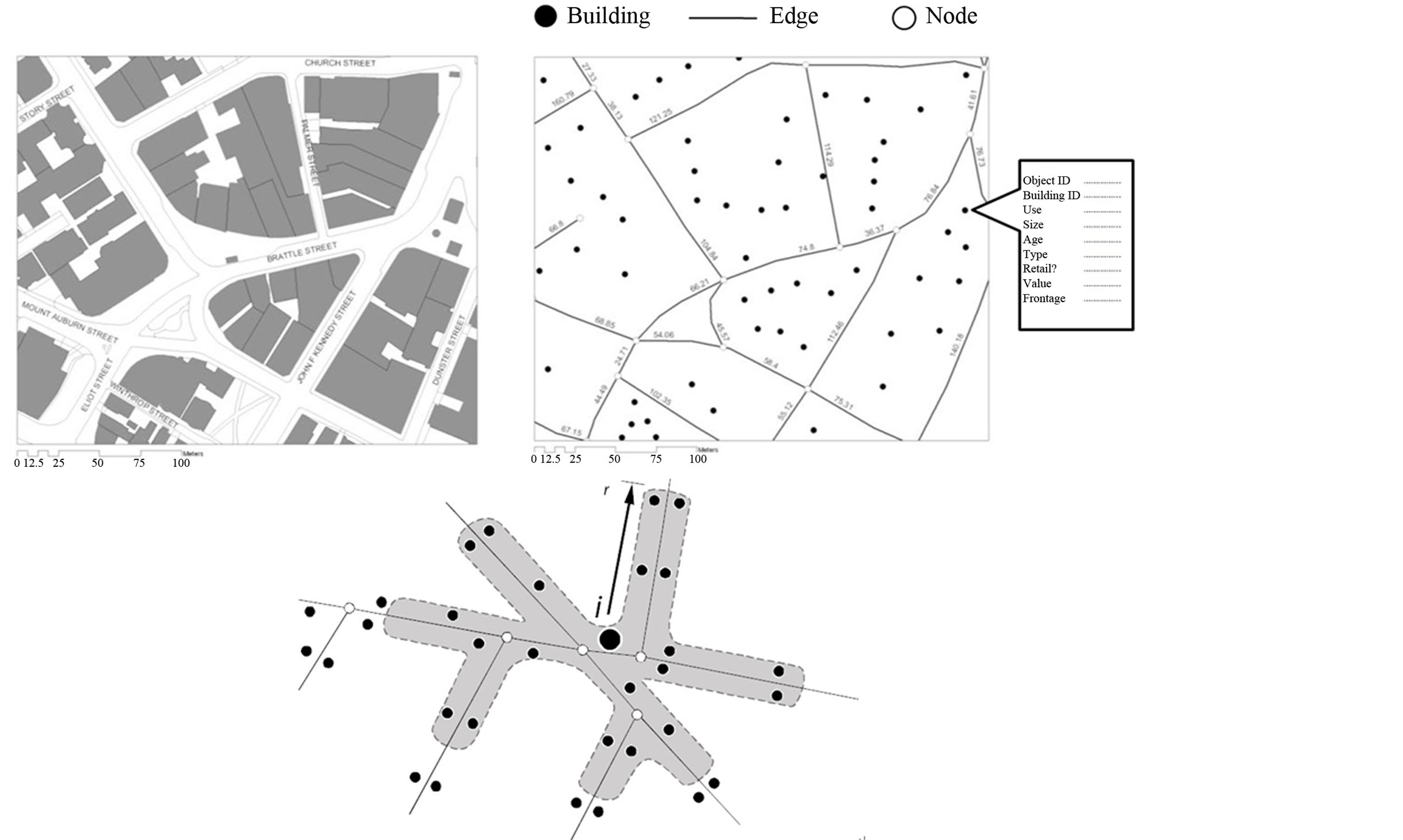
Figure 1. Principle of cumulative opportunity calculation of UNA
图1. UNA计算累计机会度量可达性原理
Step3:对区域可达性等级进行分类;
Step4:对绿色交通发展进行评估;
Step5:对绿色交通可达性影响因素进行分析。
3. 福田区绿色交通发展环境评估
本文选取深圳福田区作为评估研究案例。福田区位于深圳经济特区中部,是深圳市重点开发和建设的中心城区。截至2012年底,福田区总面积78.8平方公里,人口165.89万人,人口密度1.69万人/平方公里。本文分析对象包括福田区建筑12,807栋,选取日常生活相关的27种服务设施,将活动场所分为11大类,商店超市类型点885个,生活便利类型点794个,文化体育类型425个,学校教育类型点487个,休闲娱乐类型点1040个,邮电物流类型点280个,健康医疗类型点646个,餐饮服务类型点1873个,公共服务类型点719个,公园场所类型点65个,银行服务类型点1002个,常规公交站点731个。
3.1. 总体可达性的计算
3.1.1. 福田区服务设施的可达性
将建筑物到活动场所的距离阈值设置为600米,为步行出行可接受范围内。图2是福田区所有建筑物的服务设施可达性分布情况。图中将可达性指标分为五个等级,绿色表示建筑物所在地沿着路网到在600米范围能够到达服务设施数量少,红色表示多,介于二者之间。通过图2我们可以发现福田区步行可达性指标分布并不均匀,区域之间差异显著,东部和西南部的步行可达性最好,中部和西北部最差,可达性指标相差达到200以上,可以确定的是,在红色区域人们步行出行的意愿要比绿色区域高。
仍将建筑物到公交站点的距离阈值设置为600米,图3是福田区所有建筑物的公交站点可达性分布情况。与服务设施的可达性相比,公交站点的可达性分布较为均衡,除去福田区边界地带,公交站点可达性都较好,尤其是福田区中部地区主要为行政办公区,相对于服务设施可达性的不足,其公交站点的
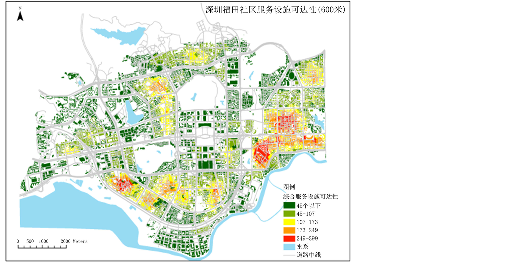
Figure 2. The walk accessibility of service facility
图2. .福田服务设施步行可达性

Figure 3. The walk accessibility of bus stop
图3. 福田区公交站点步行可达性
可达性却得到了很大的提升,极大的促进了这些区域的公共交通出行。
3.1.2. 福田区公交线路的可达性
文中选取福田区两种网络,如图4(a)所示,红色表示福田公共交通路网(不包括地铁线路),灰色表示所有机动车路网,分别计算福田区公共交通和私人小汽车的可达性。
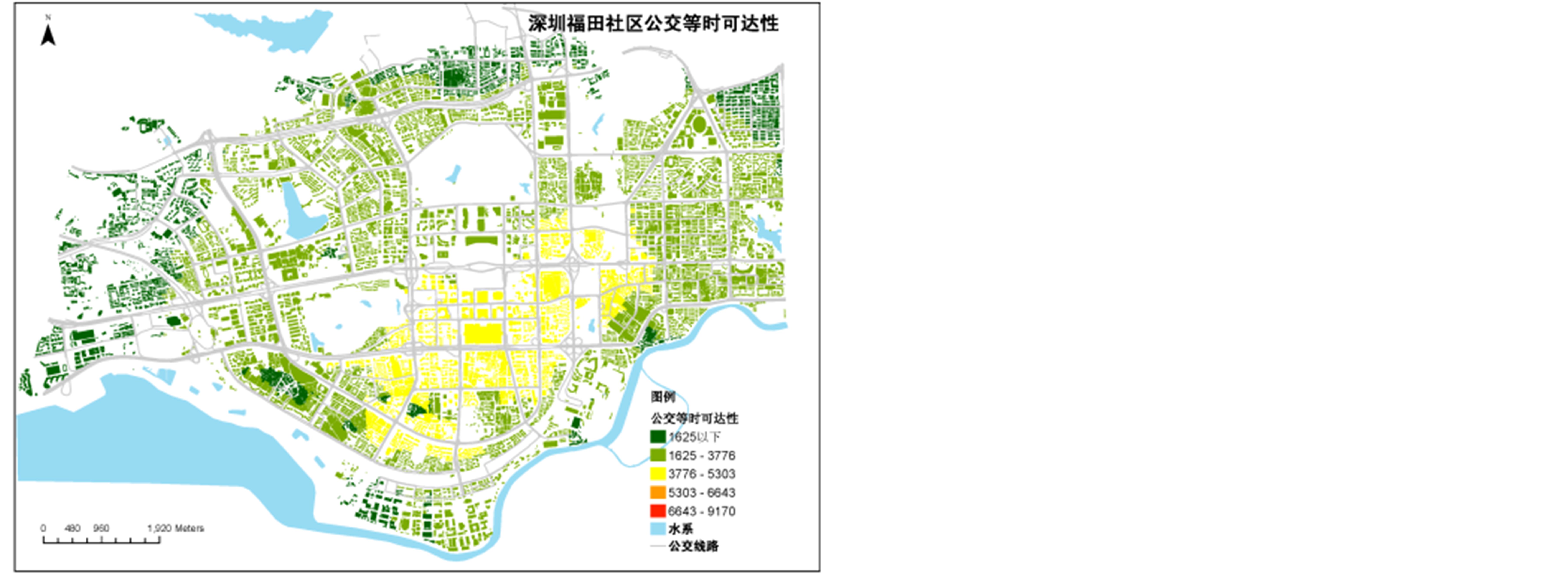
图4(b)是在一定出行距离下居民乘坐公共汽车的可达性,图4(c)是在同样出行距离下,居民采用私家车出行的可达性。通过对比发现,两者可达性差别不大分布形态基本一致,即对于同一地点来说,私家车与公共汽车出行可达性基本是一样的,说明福田了公共交通服务水平较高,体现了绿色交通中公平性。图4(d)是在同样出行时间下,公共交通的可达性分布情况,与图4(c)相比,可达性指标变小,这里
 (a)
(a)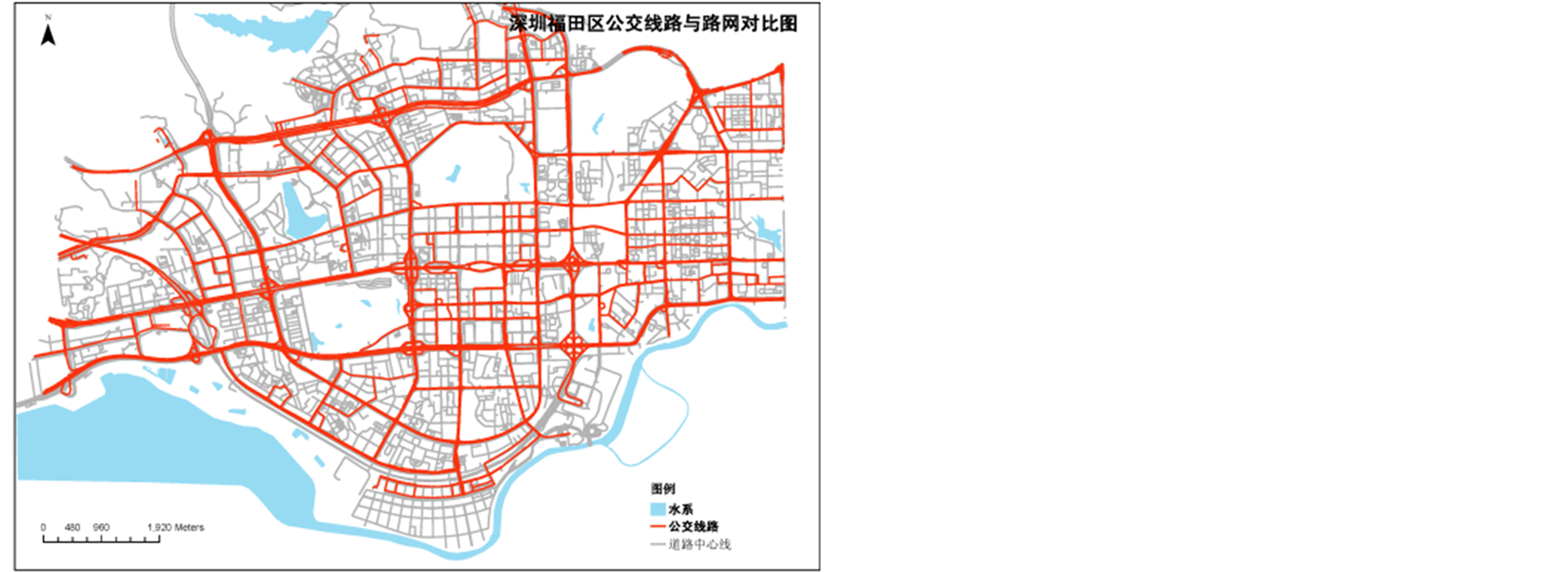 (d)
(d)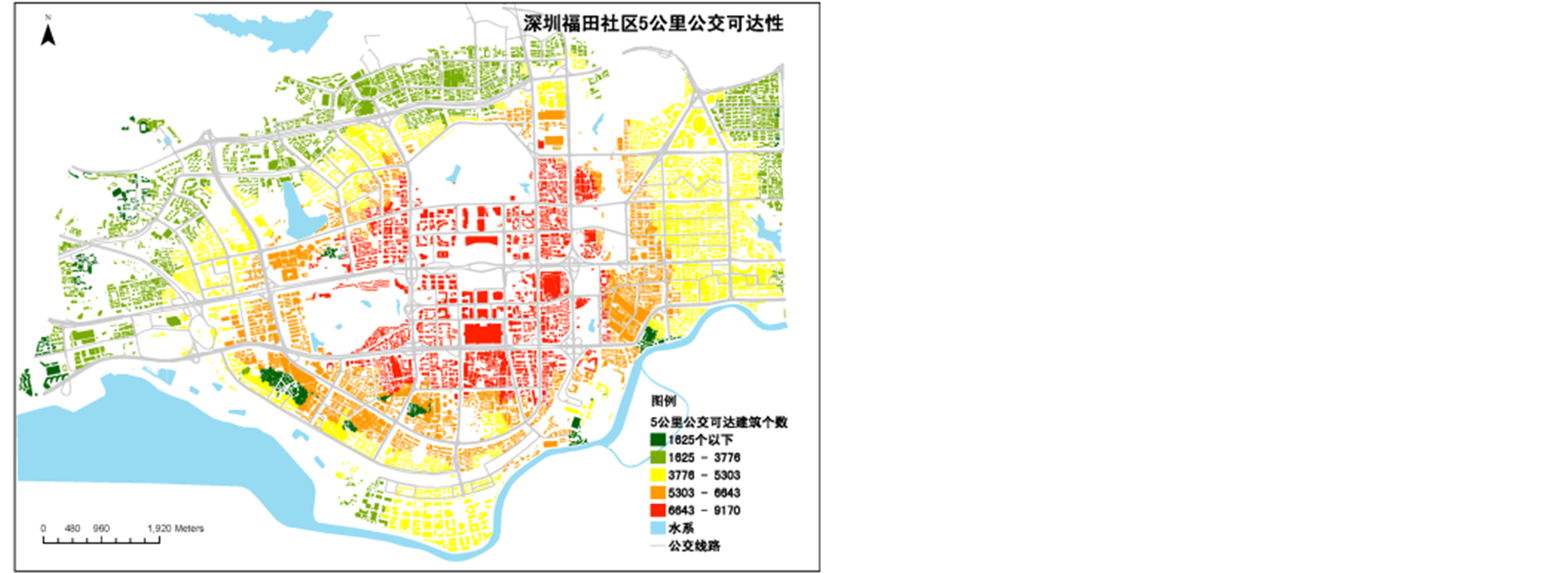 (b)
(b)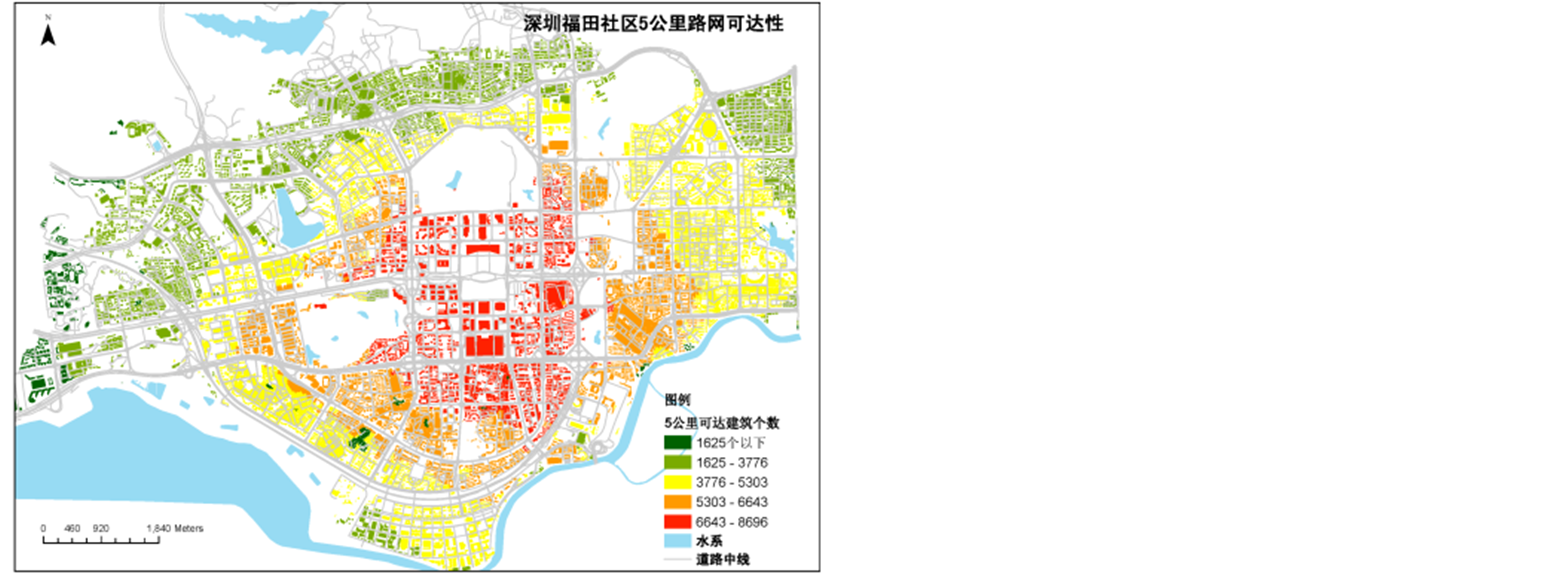 (c)
(c)
Figure 4. The bus line accessibility index
图4. 福田区公交线路可达性
面涉及到分析尺度的问题,本文篇幅所限不过多论述。
3.2. 分区评估
根据福田区域整理可达性的分布状况,分区进行区域之间的比较分析。在划分区域的时候主要考虑四个原则:(1) 以城市主干道作为片区的边界;(2) 片区之间的整体可达性要有差别;(3) 片区之间的功能性质有所差别;(4) 消除可达性计算的边缘效应,尽量不选取福田区外围地区。根据上述四个原则,选取了福田区11个社区,面积在100 ha~400 ha之间,主要分了五种功能分区,如表1所示,主要选定了7个居住区,为了便于对比,商业区,办公区,工业区和商住混合各选取了一个。
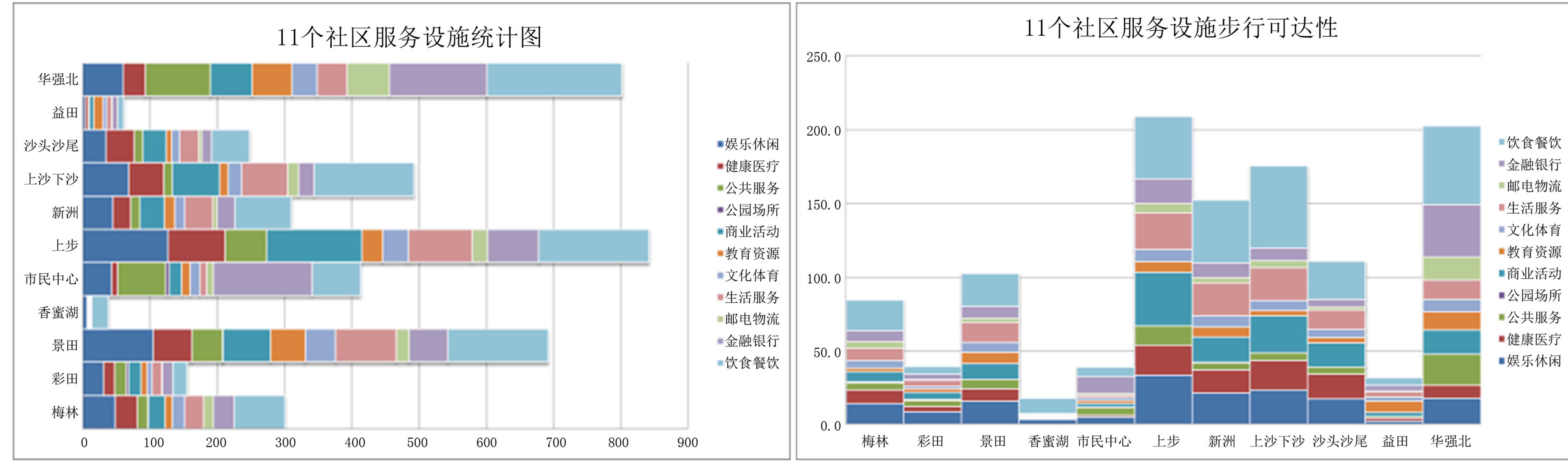
图5(a)是11个社区服务设施统计的情况,从总的服务设施数量来看,上步,华强北,景田,上沙下沙和市民中心五个社区。
11个社区可达性对比如图5(b)所示,步行可达性前五位分别是上步,华强北,上沙下沙,新洲及沙头沙尾五个社区,上步是商住混合型社区区,华强北是商业社区,其余三个为居住社区,香蜜湖步行可达性最差,与其工业社区定位有很大的关系。对商业社区华强北来说,是饮食和金融服务可达性最好;对于商住混合型社区上步来看,饮食、商业和娱乐休闲较好;对居住社区来说,除了饮食餐饮可达性外,商业,娱乐,生活服务也呈现多样化。可达性组成特征符合其社区功能定位。整体来看,饮食,商业是社区步行可达性最好的两大方面。从图5可以看出11个社区可达性排名与服务设施数量大小的排名不是
Table 1. Classification of community function
表1. 片区功能分类表
 (a) (b)
Figure 5. The comparison of community accessibility
图5. 社区可达性比较
很一致,梅林,香蜜湖,上步,益田和华强北没有差异,彩田,景田,市民中心,新洲,上沙下沙和沙头沙尾均有差异,其中办公功能社区市民中心的差异最大,差异值达到4,其余5个有差异的均为居住功能的社区。
图6是以社区为单位,社区内所有建筑物综合可达性的分布情况,从社区内建筑物综合可达性的分布状况上看,梅林、景田、上步、新洲、华强北社区建筑可达性呈现为集中对称式特征,市民中心则出现较多异常值,香蜜湖和汕头汕尾建筑物可达性分布较为不均匀。图中红线表示11个社区的平均可达性,绿线表示11个社区的可达性中位数,两条线很接近,上步,华强北中位数远远超过平均可达性,而上沙下沙,新洲及沙头沙尾中位数超过了平均可达性。分析造成社区可达性排名与服务设施数量大小的排名不一致以及社区内可达性分布不均衡的原因也是找出找出影响社区步行可达性因素的关键。
4. 讨论
根据采用的可达性计算模型,把社区步行可达性影响因素分为二大类。一类是反映在数量上,一类是反映在空间形态上。数量上的因素包括社区面积,社区道路长度,社区周边服务设施数量,社区内建筑数量,空间形态上的因素主要包括建筑物的网络聚集度,服务设施的网络聚集度。在分析这些因素时,转换为社区建筑密度,社区服务设施密度,社区周边道路密度和建筑和服务设施的最小临近距离四个因素。采用偏相关分析的方法,根据福田社区的统计分析数据,对综合可达性与四个影响因素分别求偏相关,如在求综合可达性与社区建筑密度的相关时控制其他相关因素的影响,然后比较相关系数,按四个影响因素对可达性影响程度的大小进行排序。如表2所示。
在置0.05置信水平上,可达性与道路密度和服务设施密度通过显著性检验,服务设施密度相关系数
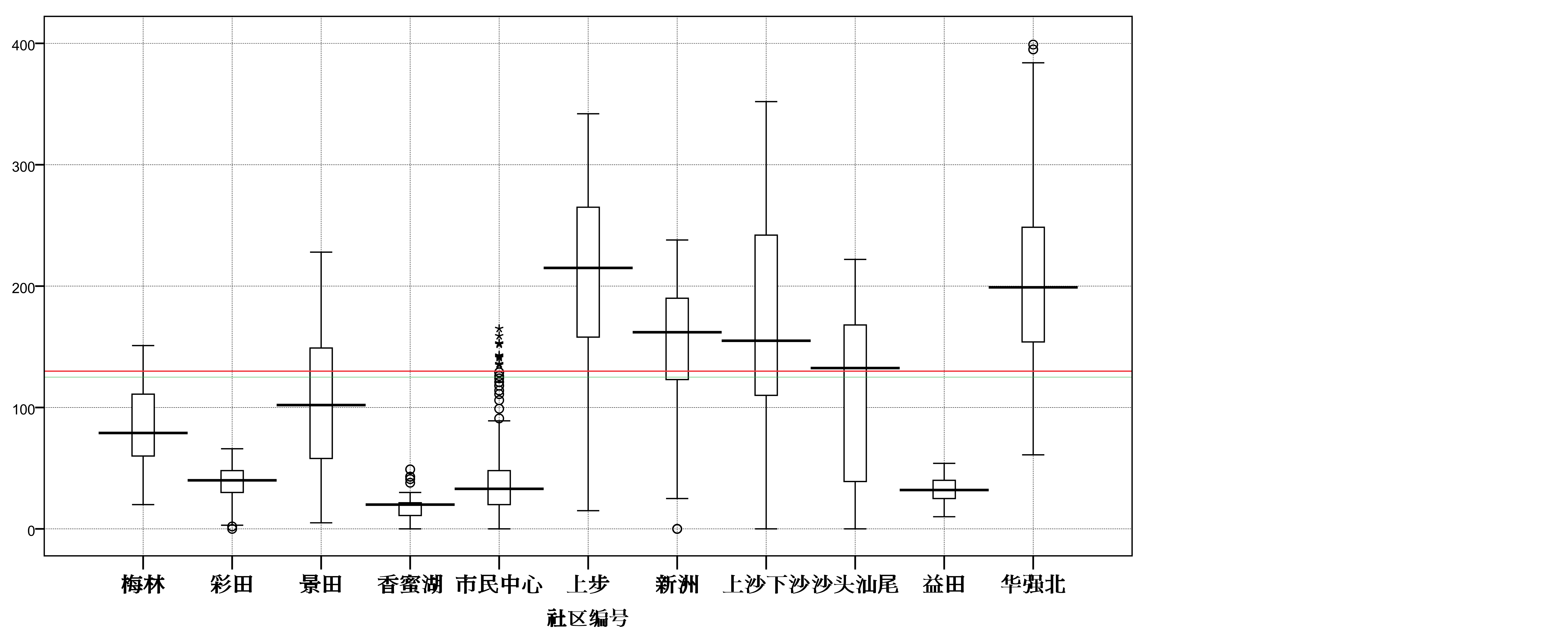
Figure 6. The index box plot of community accessibility
图6. 社区可达性分布箱图
Table 2. The partial correlation coefficients of accessibility impact factor
表2. 可达性影响因素偏相关系数
大于道路密度相关系数,对于选定的11个福田社区之间可达性差异主要是由两者引起的。建筑密度和设施最小临近距离因素没有通过显著性检验,可以认为两者对可达性的影响不大,这主要跟可达性计算模型有关,模型中是以服务设施为目标,而跟建筑物多少没有关系。但值得注意的是,11个社区的建筑数和服务设施数是显著相关的,换句话说,在现实生活中,生活服务设施设置一般倾向于建筑物多的地方,从某种程度上讲,建筑数量也影响到区域的可达性结果。
5. 结论
通过前面的研究和分析,对于福田区来说,上步,华强北,上沙下沙,新洲及沙头沙尾五个社区在服务设施的可达性,公交站点的可达性以及公交线路的可达性均较好,相比较其他区域来讲,绿色交通发展环境最好,其他区域绿色交通发展环境需要在道路密度和服务设施密度上进行提升。本文提出的评估方法只是对促进绿色交通出行进行了初步的探索和尝试,还存在许多不足,在今后的研究中,一是需要结合居民调查数据进行分析,通过实例验证理论分析;二是具体的评估模型还需要细化,以便在应用在交通规划工作中去,促进居民进行绿色出行。
基金项目
本文受到“城市社区绿色化综合改造技术研究与工程示范”课题(2012BAJ06B03)支持。