摘要:
肇庆新区是肇庆市东北部的一个新开发区,近30年来,该区域土地利用情况发生了很大的变化。作者以美国陆地卫星1990年、1995年、2000年、2005年、2010年和2015年的遥感影像为主要数据源,通过监督分类技术获得了各时相的主要地物分类专题图。在此基础上,统计地物面积,分析变化规律,探讨引起变化的主要原因。结果表明,20世纪90年代以来,肇庆新区绿地面积总体呈减少趋势,同时耕地和菜地面积也有所下降,这主要是因为城市建设用地的迅速增加占用了较多的土地;而水域出现了持续增加,主要是人们对水产品需求的增加导致的鱼塘的增加,它在一定程度上反映了当地经济正在快速发展,人们的饮食结构也在不断发生变化,不再满足仅仅依靠粮食维持温饱的生活状态。
Abstract:
Zhaoqing New District is a new development zone in the northeast of Zhaoqing City. In the past 30 years, the land use situation has changed greatly. The author uses the remote sensing image of Landsat satellite in 1990, 1995, 2000, 2005, 2010 and 2015 as the main data source, and obtains the main feature classification map of each phase by the technology of supervision classification. On this basis, the statistical area of land and analysis of changes in the law have been done to explore the main causes of change. The results show that since the 1990s, the green area of Zhaoqing New Area has been decreasing, and the areas of cultivated land and vegetable land have also decreased. This is mainly due to the rapid increase of urban construction land and the occupation of more land. The increase is mainly due to the increase in aquatic products caused by the increase in demand for aquatic products. It reflects to some extent that the local economy is developing rapidly and that people’s eating structure is constantly changing and no longer depends on food and food living condition.
1. 引言
卫星遥感技术是当前用于城市用地动态变化监测的最主要技术 [1] [2] [3] [4] ,不仅可以经济快速获取城市用地变化数量信息,还可以获得城市用地变化的位置信息,甚至可以进行驱动力分析 [5] [6] 。美国陆地卫星系列具有中等分辨率、多波段、长期持续观测的特点,受到了城市研究者的青睐 [7] [8] [9] 。
肇庆市新区是肇庆市发展较快的一个新城区,近三十年来,随着肇庆市经济的快速发展,肇庆新区的城市用地也发生了很大的变化。作者利用先进的卫星遥感技术,获取了肇庆新区城市土地动态变化信息,分析城市土地变化规律,探索变化原因。
2. 数据来源和研究方法
2.1. 研究区概况
肇庆新区位于广东省肇庆市,地处鼎湖区中部,东邻肇庆国家高新区和佛山市三水区,南靠高要区,西倚端州区,北接四会市,是肇庆市各功能区紧密连接的主要纽带,是广佛肇经济圈的重要发展腹地,也是珠三角联通大西南各省区的重要交通节点,地理坐标为东经112˚33'33.3''~112˚41'32.7'',北纬23˚09'34''~23˚15'084'',规划区面积约115 km2。
2.2. 数据源及预处理
1) 数据源
土地动态变化监测一般需要观察较长时间段内地物的变化状况。美国陆地卫星是中等分辨率的对地观测卫星,它由先后发射的多颗卫星(目前已发射8颗)组成,具有对全球范围长期动态观测的特点。本次研究工作,希望获得肇庆新区1990年以来的土地变化信息,其中,Landsat5的TM数据(1984年~2013年)、Landsat7 (1999年~2003年)的ETM+数据和Landsat8 (2013年至今)的OLI数据的获取时间满足要求。TM、ETM+和OLI数据包含了从可见光到近中红外谱6~7个波段,其空间分辨率均为28.5 m (或30 m)。因此,这些遥感数据波谱分辨率和空间分辨率均能够满足城市土地动态变化的监测的需要。
本次研究从美国地质调查局(USGS)网站免费下载了肇庆地区不同时相的美国陆地卫星遥感数据6景,其时相分别为:1990年12月07日、1995年11月03日、2000年12月02日、2005年09月11日、2010年12月30日及2015年11月26日年,均为冬季11月~12月份,具有相似的成像条件,地物可比性强,有利于进行对比研究。而且影像清晰,无云覆盖,适合于土地动态变化监测。此外,为了对变化较大的重点观测区域进行了详细对比研究,从Google earth中下载的多时相高分辨率遥感数据也是十分重要的补充 [10] 。
2) 预处理
为了进行准确对比研究,将所获得的6景不同时相的Landsat卫星遥感数据可见光、近中红外波段分别进行严格配准,并根据坐标切取与肇庆新区完全一致的影像子区,作为下一步图像分类研究的数据源。将下载的高分辨率遥感数据进行增强处理后作为插图使用。
2.3. 图像分类处理
城市用地变化监测一般在利用高分辨率影像进行城市地物遥感解译的基础上,采用中等分辨率遥感数据,通过计算机自动分类 [11] [12] 或信息提取 [13] 的方法,可以快速了解土地变化情况。本次工作选择了1990年、1995年、2000年、2005年、2010年和2015年6个时相的TM、OLI卫星影像数据,采用遥感影像监督分类技术,对城市主要用地进行分类,并制作了6个时相的肇庆新区城市用地遥感分类专题图(图1),分类结果能够较好的反映城市用地变化。
3. 土地动态监测及驱动力分析
3.1. 土地动态监测
本次土地动态监测是通过卫星遥感数据获取变化信息,具体实现过程为:先将肇庆新区主要地物分为水域、建筑用地、绿地、菜地、空地等6类;然后,在影像中选择这6类地物的训练样本;最后,利用监督分类方法肇庆新区遥感影像进行分类,制作肇庆新区城市用地分类专题图;并对分类结果进行了统计,制作肇庆新区城市用地变化规律图。
3.2. 驱动力分析
从肇庆新区城市用地遥感分类专题图(图1)、分类结果统计表(表1)和变化规律图(图2)可以看出,肇庆新区分布面积最大的地物是绿地,主要是因为西北的北山面积较大,占了整个区域约1/3左右,绿地面积总体呈下降趋势,主要是鼎湖山东南麓和永安镇北低山较大面积的林地被开发为建设用地,通过高清影像对比,就可以发现2016年建设用地(图3(a)中红色框内)较2006年建设用地(图3(b)中红色框内)面积明显增加;此外,鼎湖山东南麓大量采石也破坏了较多植被,2016年的采石场(图3(c)中红色框内)较2006年的采石场(图3(d)中红色框内)面积增加了几倍;其次是耕地,1995年前,约占总面积27%,2000年后,迅速降低至16.16%,这主要是因为2000年前,肇庆新区基本还处于未开发状态,1995年~2000年间,肇庆新区得到快速发展,大量耕地被占用为建筑用地;再其次就是水域,其面积总体呈上升趋势,
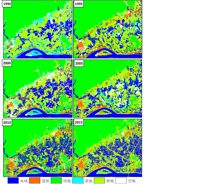
Figure 1. Remote sensing image classification of land in Zhaoqing new district from 1990 to 2015
图1. 1990~2015年间肇庆新区用地遥感影像分类图
Table 1. Statistics of remote sensing image classification of urban land in Zhaoqing new district
表1. 肇庆新区城市用地遥感影像分类结果统计表

Figure 2. The law of urban land change in Zhaoqing new district
图2. 肇庆新区城市用地变化规律图
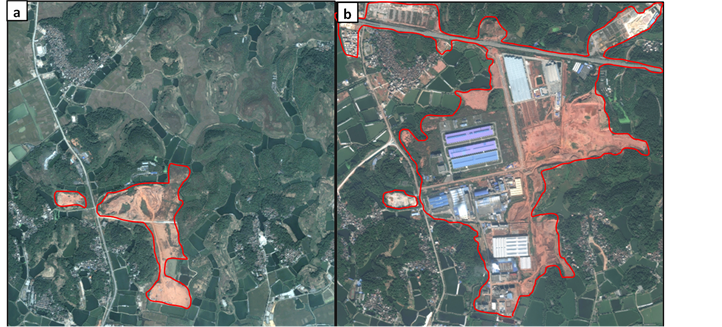


Figure 3. Comparison of urban land change images in Zhaoqing new district (The left time is November 6, 2006; the right column is December 17, 2016)
图3. 肇庆新区城市用地变化影像对比图(左列时相为2006年11月6日,右列时相为2016年12月17日)
主要是人们对水产品的需求增加导致大量农田被改造为鱼塘,2016年的耕地(图3(e)中红色框内)较2006年的耕(图3(d)中红色框内)地面积减少了很多;再就是建筑用地,1990年时,肇庆新区基本还没有开发,总建筑面积不到2%,在后续的10年中,建筑面积迅速增长,2000年达到接近10%,之后便进入一个稳定的发展期,2015年达到13.17%;菜地和空地则出现波浪式的发展,1990年~1995年间,由于建筑用地的急剧增加,较多的菜地被用于修建房屋,导致菜地面积迅速减少;1995年~2005年间,随着城市人口的不断增加,对蔬菜的需求也持续增长;2005年后,随着建筑用地和鱼塘的增加,菜地则出现持续减少,蔬菜供应则只能更多依靠新区之外的农村;空地相对变化平缓,2000年后,肇庆新区发展迅速,随着建筑用地的增加,空地持续减少;但2010年后,可能是因为部分菜地外迁导致空地出现短暂增长。
4. 结论
利用美国陆地卫星遥感数据监督分类专题图,对肇庆新区土地利用动态情况监测分析,取得了以下主要认识:
1) 美国陆地卫星系列获得的遥感数据是目前时间跨度最长的卫星数据,其波谱分辨率和空间分辨率非常适合于长时间较大面积的土地变化动态监测;
2) 通过肇庆新区的30年土地动态变化分析,发现了肇庆新区不同于其他城市区发展的一个重要特征:水域面积出现了持续较大的增长;
3) 重点分析了肇庆新区水域面积持续较大增长的主要驱动力是水产养殖的增加导致的鱼塘面积的增加,这对肇庆新区的城市规划具有重要参考价值。
基金项目
广东省肇庆市肇庆新区城市地质调查项目资助。